

relief map


 1
3.9
1
3.9
- noun
- /rɪˈlif mæp/
- The relief map clearly illustrated how the terrain varied across the region, with deep valleys and steep hills.
Examples
-
By the time Park caught up, the others were already on the fifteenth tee, a long par-four, according to the carved wooden marker that featured a colorful relief map of the dogleg ahead.
Fiction book (2001) -
Thunder boomed over the next peak as she recalled the relief map in her atlas depicting the ridge of the Carpathians that lay before her, a terrifying obstacle she hadn't let herself think about.
Fiction book (2002) -
The teacher used a relief map to show the students the different elevations of the mountains.
-
During the presentation, we studied a relief map that highlighted the shape and height differences of the land in the area.
Synonyms
 ∞
1.0
∞
1.0
A drawing that shows where roads and towns are
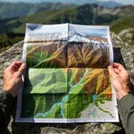 1
8.4
1
8.4
A map that shows the shape of land and its height
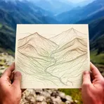 1
3.5
1
3.5
A map that shows land height and shape using lines that join places at the same height
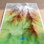
A detailed map that shows land shape and features like hills and rivers
How Three-Dimensional

Surface Forms
Morphology
The compound follows a transparent noun+noun pattern (X map = a map showing X), so if a learner understands 'relief' in the geographic/surface-elevation sense (or as 'raised/protruding shape') they can derive that it is a map showing land height and shape. However, 'relief' has several common senses (e.g., relief as 'help/ ease' or 'sculptural projection') that many B1 learners may know instead, so the specific geographic sense is not fully predictable without some exposure.
Etymology
Relief map comes from the word relief, meaning the raised or high parts of the land, and the map that shows them. Imagine hills and mountains pushed up or shaded on the surface so you can see where the land is high or low, and you will see why a relief map means a map that 'shows the height and shape of the land'.