

polyconic projection
- noun
- /ˌpɒlɪˈkɒnɪk prəˈdʒɛkʃən/
- Specialized
- Unlike the Mercator projection, the polyconic projection preserves true distances along the central meridian.
Examples
-
The polyconic projection is often used for large-scale mapping of countries.
-
The polyconic projection is useful for mapping regions with large east-west extents.
-
Many nineteenth-century atlases featured maps drawn using the polyconic projection.
-
Many cartographers prefer the polyconic projection for its accuracy.
-
Many nineteenth-century atlases featured maps drawn using the polyconic projection.
-
The polyconic projection is often used for large-scale mapping of countries.
-
Many cartographers prefer the polyconic projection for its accuracy.
Synonyms

 7
4.6
7
4.6

A flat drawing that shows an object from one view

A map that shows the Earth's surface on a cone placed over the globe
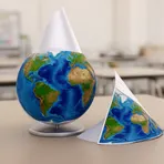
A way to make a flat map by copying Earth onto a cone over part of the globe

A method for drawing the Earth's round surface on a flat map that changes shapes or sizes
Surface Forms
Morphology
polyconic + projection
The headword 'projection' clearly signals a type of map depiction, so a learner who knows that constituent will infer this is a kind of map projection. However 'polyconic' is a technical, morphologically complex term (poly- 'many' + conic 'cone-like') that most B1 learners will not parse or link to the specific construction of parallels as circular arcs, so the precise meaning is not fully predictable. Thus the combination yields partial transparency: the general category is clear but the specialized sense requires prior exposure.
Etymology
Polyconic projection comes from mapmakers imagining many small cones touching the globe. Poly means 'many' and conic means 'cone', and using a cone for each latitude made each parallel into a short curved arc on the map. So the projection keeps correct distances along those 'parallels'.