

conic projection
- noun
- /ˈkoʊnɪk prəˈdʒɛkʃən/
- Specialized
- The conic projection is often used for mapping mid-latitude regions because it balances area and shape distortion.
Examples
-
Many road and weather maps are based on a conic projection to accurately represent larger areas.
-
When creating her atlas, the cartographer chose a conic projection for optimal representation of the continent.
-
The conic projection is useful for mapping mid-latitude regions.
-
Many cartographers prefer the conic projections for their accuracy.
-
Many road and weather maps are based on a conic projection to accurately represent larger areas.
-
The conic projection is often used for mapping mid-latitude regions because it balances area and shape distortion.
-
When creating her atlas, the cartographer chose a conic projection for optimal representation of the continent.
Synonyms
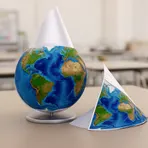
A way to make a flat map by copying Earth onto a cone over part of the globe
Surface Forms
Morphology
The term is compositionally transparent: it denotes a projection that is cone-shaped, directly combining 'conic' (having the form of a cone) with 'projection' (a depiction or mapping). A learner who knows both constituents can infer it refers to a map projection using a cone, even if some technical construction details remain specialized.
Etymology
Conic projection: The conic part comes from a paper cone placed over a globe, and the projection part is the act of copying the globe's surface onto that cone; mapmakers used this simple picture to make a map. When they flatten the cone, the image becomes a 'map', so the term means a type of 'map' made by projecting the Earth onto a cone, which fits wide areas that are not near the equator or the poles.

