

GIS
 17
4.9
17
4.9

- noun
- /dʒiː aɪ ɛs/
- Specialized
- Collaborative efforts could lead to creative and practical applications of GIS technology to answer complex environmental epidemiologic research questions.
- geographic information system
- GIS technology
- GIS information system
Loading YouTube…
Watch on YouTubeSo doing real estate, you need to have access to the local counties, register of deeds, their GIS mapping, all of those things.
- So doing real estate, you need to have access to the local counties, register of deeds, their GIS mapping, all of those things.
- There's a section at the beginning on computation and also on the GIS.
Examples
-
The following three examples illustrate the use of several specialized GIS functions for environmental exposure assessment in population studies.
Academic text (1998) -
One of the most powerful features of a GIS is the ability to overlay several map layers.
Academic text (1998) -
The full potential of GIS technology in health research is not yet known.
Academic text (1998) -
Some questions to consider when selecting a GIS software product include:
Academic text (1998) -
Despite their weaknesses, the above studies represent innovative uses of GIS technology for exposure assessment in environmental health research.
Academic text (1998) -
Data can be stored in a GIS in two ways: in raster format and in vector format.
Academic text (1998) -
We've worked with GIS experts to map access to banking and remote working hubs and hospital driving times.
-
Arc/Info is an example of a powerful workstation GIS product; a PC version also exists.
Academic text (1998) -
Growers in Arkansas, Louisiana, and Texas are interested in applying the GIS in their states.
Academic text (1994) -
One of the most powerful features of a GIS is the ability to overlay several map layers.
Synonyms
 1
4.6
1
4.6
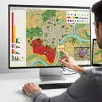
A computer program that stores, analyzes, and shows maps and data about places
How Complex

Surface Forms
Morphology
GIS = G + I + S
GIS is an initialism/acronym formed from the initial letters of a multiword name; the letters are not productive English morphemes, so knowing them does not allow learners to derive the meaning.
Etymology
GIS is short for Geographic Information System, and the geo- part means 'earth', just like in geography, so you can think of it as a computer system for maps and place data. That's why a GIS is used to store, work with, and show geographical information about locations and places.